Every scene, as a spreadsheet, a map and a feed.
The facts behind HYAKKEI's 73 published scenes in files you can open, plot or import: coordinates, the month-by-month calendar, access difficulty, the trip receipt, and the month each page was last checked. Free under CC BY 4.0, and regenerated every time a scene is published.

At a glance
Figures are read from the files themselves, so they are as current as the download.
- Scenes
- 73 of 100No.1 Ginzan Onsen to No.77 Atami Onsen, Atami
- Prefectures
- 46Aichi to Yamanashi, alphabetically
- Columns per scene
- 35in the CSV; the calendar takes twelve of them
- Formats
- 7JSON, CSV, GeoJSON, GPX, KML, SVG, PNG
- Version
- 2026.09.1archived under a DOI
- Busiest month
- November34 scenes at full strength
- Median trip receipt
- ~¥48,000per person, on the basis printed on each page
- License
- CC BY 4.0commercial use allowed, credit required
- Updated
- October 2026with every build of the site
Downloads
The scene list in six shapes, plus two things that are not the scene list: a separate record of one mountain's autumn, and the citation file. Sizes are for the current list.
| File | What it is | Best for | Size |
|---|---|---|---|
| hyakkei.json | Everything, one object per scene, plus the count and license at the top | Scripts, apps, AI tools | 101 KB |
| hyakkei.csv | One row per scene, UTF-8, the calendar spread across twelve columns | Excel, Google Sheets, Numbers | 33 KB |
| hyakkei.geojson | A point per scene with the fields you would put on a map | Leaflet, Mapbox, QGIS, Google My Maps | 36 KB |
| hyakkei.gpx | Waypoints with the scene name, a one-line description and a link back | Organic Maps, Gaia GPS, Garmin, camera GPS | 33 KB |
| hyakkei.kml | The same points, but each pin opens with the photograph, the best window and a link | Google My Maps, Google Earth | 101 KB |
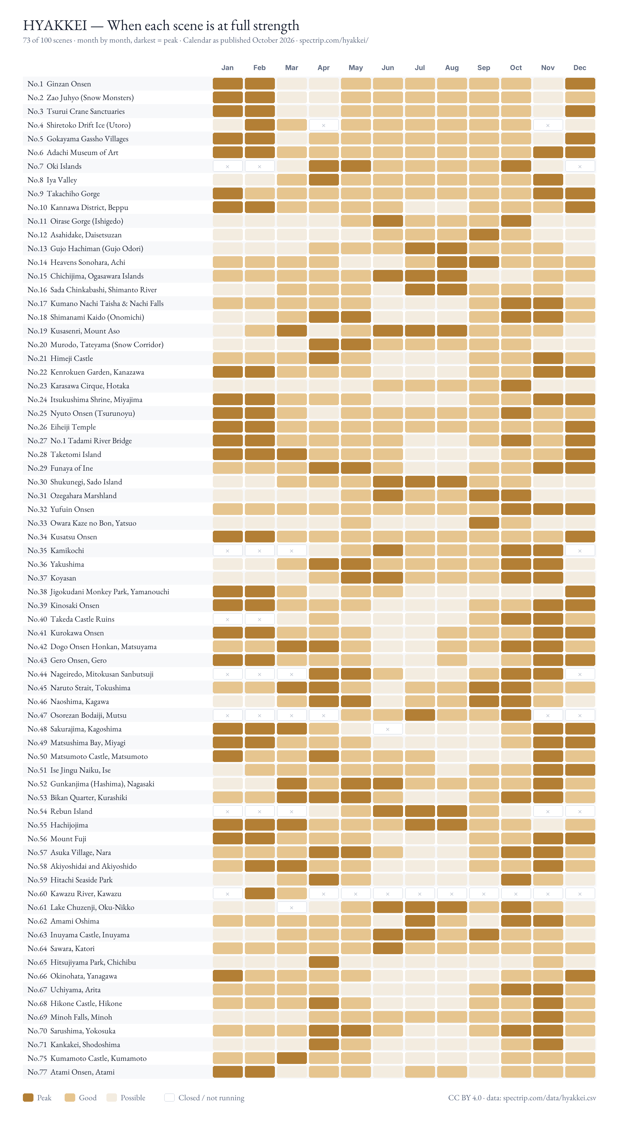
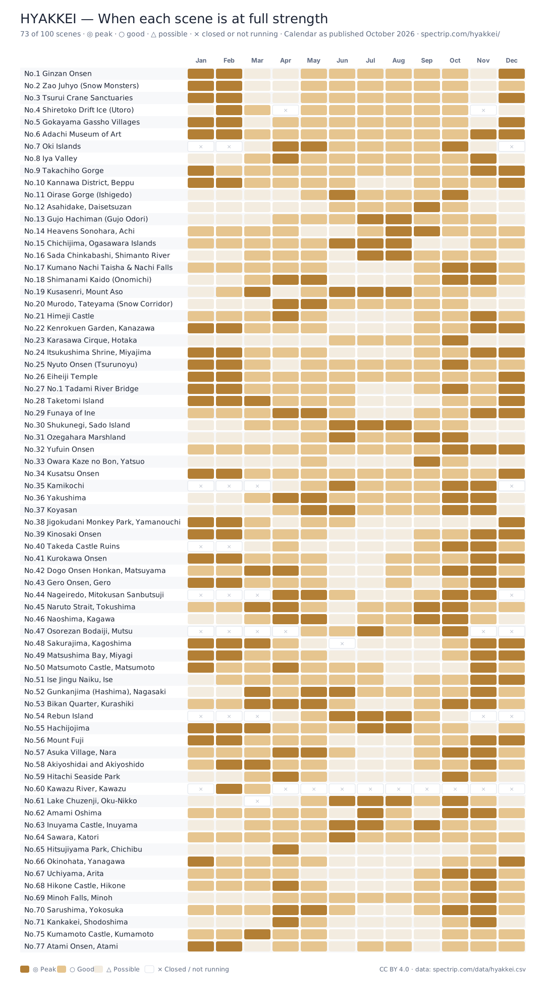
| heatmap.svg heatmap.png | The calendar chart below, every scene by every month | Embedding, slides, print | 155 KB / 564 KB |
| foliage-karasawa.csv | Not the scene list. One row per daily autumn report from the Karasawa Hyutte, a hut at 2,300 m in Japan's Northern Alps, with our reading of what it said | Phenology, seasonality, forecast checking | 3 KB |
| foliage-okunikko.csv | Not the scene list. One row per autumn-color post from the Nikko Yumoto Visitor Center at Oku-Nikko since 2010, with our reading of each use of migoro, the word for “at its best” | Phenology, seasonality, forecast checking | 57 KB |
| README.md | Field definitions, which columns are measured and which are our judgment, and the license | Reading first | 17 KB |
| CITATION.cff | How to cite this, in a form reference managers read. Version 2026.09.1 | Papers, reference managers | 1 KB |
Not in this folder but part of the set: /feed.xml, an RSS feed of scenes as they are published, and /llms.txt, an index written for AI assistants.
The year, in one picture
When each scene is at full strength. Darkest is peak, lightest is possible, an × is closed or not running. Rows are publication order, not a ranking.
Embed it
<a href="https://spectrip.com/data/"><img src="https://spectrip.com/data/heatmap.svg" alt="HYAKKEI: when each of the hundred scenes of Japan is at full strength, month by month" width="1100"></a>
The SVG is live: it redraws itself with new scenes on every build, so an embed never goes stale. The license line is drawn into the image.
What is in it
Field names are identical across JSON and CSV. In the CSV the calendar becomes cal_jan to cal_dec.
| Field | Meaning |
|---|---|
| no | Scene number, 1 to 100. Publication order, never reassigned |
| title, place, prefecture, region | Page title, the landmark's name, prefecture, and the region used on the site |
| lat, lon | Approximate landmark coordinates (WGS84). Not the photo spot; that is under "Where to Stand" on the page |
| coord_checked | The date we cross-checked that point against Wikidata and OpenStreetMap. Blank means not re-checked, which is not the same as wrong |
| url | The scene page. Permanent |
| best_window, peak_months | The "Best:" badge on the page, and the months marked ◎ on its calendar |
| calendar | Twelve values: ◎ peak, ○ good, △ possible, × closed or not running, blank if unrated |
| access_level | 1 easiest to 5 hardest, as shown on the page |
| budget_level, budget_jpy_low, budget_jpy_high, budget_basis, budget_text | The Estimated Cost total, per person, on the basis stated (usually Tokyo round trip plus one night with dinner and breakfast) |
| tags | Theme badges: Onsen, Heritage, After dusk, and so on |
| checked | Month the page's facts were last verified, as YYYY-MM |
| date_published, date_modified | Page dates |
| reddit_threads_cited | Number of Reddit threads quoted in "From the Threads" |
| review_rating | Visitor review score out of 5, when a review is published |
| hero_image | Hero photo URL, for reference. Photo licences vary and are on the page |
| hook | The one-line description from the list |
Six ways to use it
Google Sheets, one formula
Paste this into A1 and the sheet fills itself, and refreshes as the list grows.
=IMPORTDATA("https://spectrip.com/data/hyakkei.csv")
Leaflet, a few lines
The GeoJSON loads cross-origin; no key, no proxy.
fetch("https://spectrip.com/data/hyakkei.geojson") .then(r => r.json()) .then(g => L.geoJSON(g, { onEachFeature: (f, l) => l.bindPopup(`<a href="${f.properties.url}">No.${f.properties.no} ${f.properties.place}</a>`) }).addTo(map));
Every scene on your offline map
Import hyakkei.gpx into Organic Maps, Gaia GPS or a Garmin. Each waypoint carries the scene's one-line description and a link back to the page.
A shareable map in two minutes
Ours is already there: every scene on one map, colored by region. To build your own, create a map and import hyakkei.kml. Every pin opens with the photograph, the best window and a link to the scene. Set the style to Region and the map colors itself by part of the country. Import hyakkei.csv instead if you want the full set of columns to style by.
No server needed
The JSON is a static file with CORS enabled, so a page can read it directly.
const d = await (await fetch("https://spectrip.com/data/hyakkei.json")).json(); console.log(d.count, d.scenes[0].title);
New scenes as they land
Subscribe to spectrip.com/feed.xml in any reader. One item per scene, with the hero photograph.
Read the numbers carefully
- Coordinates mark the landmark, not the spot to stand. The exact spot, and the hour, are in "Where to Stand" on each page.
- The calendar is editorial. ◎ means the scene itself is at full strength, not that the weather is good. × means something the scene depends on is closed or not running in that month: a bus, a boat, a light-up.
- The trip receipt is a planning figure. Per person, on the basis printed on each page, usually a Tokyo round trip plus one night with two meals. It was checked in the month shown, and it moves.
- checked is a date, treat it as one. Anything older than six months deserves a second look before you trust a fare or a timetable.
- Numbers are publication order. No.1 is not the best scene. There is no ranking in this data because there is none on the site.
- access_level is a judgment, not a measurement. It weighs transfers, walking, timetables and weather together, so do not use it as a stand-in for distance or journey time.
- foliage-karasawa.csv ends where the reporting ends. The hut stops posting when its season closes, so the last date in a season is not the day the color finished. Ten of its rows are photograph-only posts and carry no flags. The README sets out the rule we used to read the words.
- foliage-okunikko.csv records a word, not a measurement. Each row is one post. The tables on the site take, for each year, the first post that said a place was at its best; the center posts every few days, so the real start may be earlier. The README sets out the rule.
- Photographs are not in the data and not under this license. Each carries its own credit on the scene page.
How to cite this
For a paper or a dataset reference. For a product or an article, the credit line under License below is enough.
Suzuki, Y. (2026). HYAKKEI: 100 Scenes of Japan (open data) (Version 2026.09.1) [Data set]. SPECTRIP. https://doi.org/10.5281/zenodo.22861242
That DOI resolves to the archived copy of this version, which does not change. Every version has its own DOI, so cite the one you actually used. The machine-readable version is CITATION.cff.
License and credit
Creative Commons Attribution 4.0. Use it, change it, sell what you build on it. Say where it came from, and say if you changed it.
Credit line
Data: SPECTRIP HYAKKEI (spectrip.com/data/), CC BY 4.0.
A link to spectrip.com/data/ or to the scene page is the credit we would choose. The license covers the data files and the chart. It does not cover the photographs, the text of the scene pages, or the HYAKKEI and SPECTRIP names and marks.
Built with this data
Maps, charts, tools and articles that use it. If you publish one, send us the link and it goes here.
Nothing listed yet. The first one gets the top line.
Questions
Can I use the data in a commercial product?
Are the photographs included?
How often is it updated?
Why are some months blank or marked ×?
Is there an API?
Can I ask for a field?
One address answers
Corrections, field requests, and links to what you built. We reply within two working days.
hello@spectrip.com